<< School | Rwanda >>
Mount Elgon National Park and Sipi Falls
11th - 16th December 2004
After 6 weeks of lethargy in Kampala, I decided that it was time to get some training in otherwise the Rwenzori Mountains would eat me alive in January. So I headed for Mt Elgon National Park to try and get a bit fit again. What I didn't realise was just how unfit I'd become.
Our trek started in the village of Budadiri in Eastern Uganda. The beginning of December is circumcision season in this part of the country and there were 3 processions dancing up and down what qualifies as Budadiri's main street, banging drums, chanting and generally just enjoying themselves.
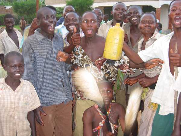
The scared looking lad at the bottom of the picture waving the horse tail things is the one about to get the snip. But he has to put up with a couple of days of being paraded around the village first (exactly how long depends on how brave he is), before the deed is carried out in 3 cuts (without anaesthetic) and he is then left to recover for about a week.
The following morning I set off into the national park, pleased that it wasn't me that was the focus of the festival's attention in the village. I was lucky to meet a couple of English doctors (Mike (aka Huckleberry Finn) and Cariad) who were doing the same trek as me, so we trekked together and I was glad of the company. We trekked for about 8 hours on the first day and climbed 2250m and were exhausted by the time we reached Mude Cave camp, where we were to spend the night.
The next morning we set off for Wagagai Peak, which is the highest point on Mount Elgon. The day was made harder by the blisters that I'd acquired yesterday and which continued to bother me until about 2 days after I got back to Kampala.
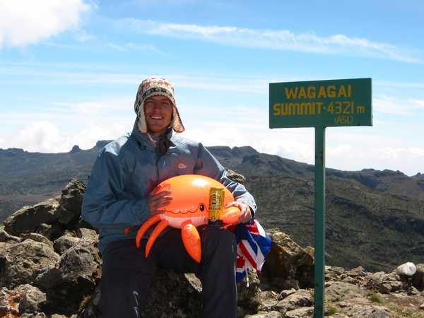
This is Clarence and me at the summit of Mt Elgon. This peak is called Wagagai peak and is 4321m above sea level. It was quite windy and pretty cold at the summit, but it was pleasantly warm when you got out of the wind. And yes, that is a can of Boddingtons that Clarence is holding : ) We also went to Jackson's Summit on our way back to camp, which wasn't as high, but much steeper and a good scramble.
The following morning, Mike and I set off to cross to the other side of the crater to see the Suam gorge and the hot springs. Cariad wisely decided to have a rest day, but being slaves to testosterone, Mike and I obviously couldn't do such a thing : )
The landscape in the crater was stunning. Small cliffs jutted up from the crater floor, which was covered in little palm trees and crossed by small streams and was quite boggy in places.
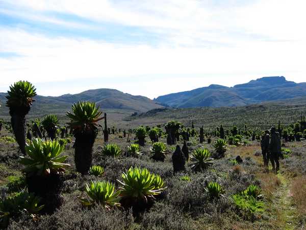
In the picture, the mountains in the distance are the rim of the crater, cut in the middle by the Suam Gorge and in front of us on the path are our guides and park rangers. Sadly there isn't much wildlife on the Ugandan side. Much of it was machine gunned for food during Idi Amin's rule and the war which subsequently ended his rule. The park hasn't been in existence for long enough for the wildlife to recover, but it is hoped that the animals will slowly make their way back here from Kenya.
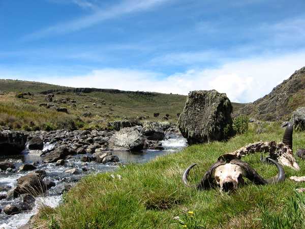
The hot springs weren't that impressive in themselves (just some hot water bubbling out of the ground and trickling down the rocks). However there was plenty of evidence of the buffaloes which come here to drink the salty, mineral-rich water of the hot springs (hoofprints and buffalo dung).
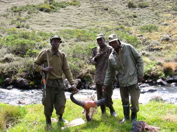
Sadly, there was also evidence of the poachers who come here to kill the buffaloes for their meat. In the picture our guides are holding the skull of a buffalo (one of 3 carcasses that were there). The guides (from L to R: Isiah, Albert and Paul) carry Ugandan made Kalashnikovs which they use to scare the poachers.
An arty shot looking out of the Suam gorge into the crater. The stream marks the border between Uganda and Kenya (Uganda is on the right and Kenya is on the left). Our guides were very strict about not letting us set foot on the other bank without the permission of the Kenyan authorities. Further down the gorge in Kenya are some large caves with big salt deposits. Elephants feel their way into these caves in the dark to feast upon the salt (and poachers also go there).
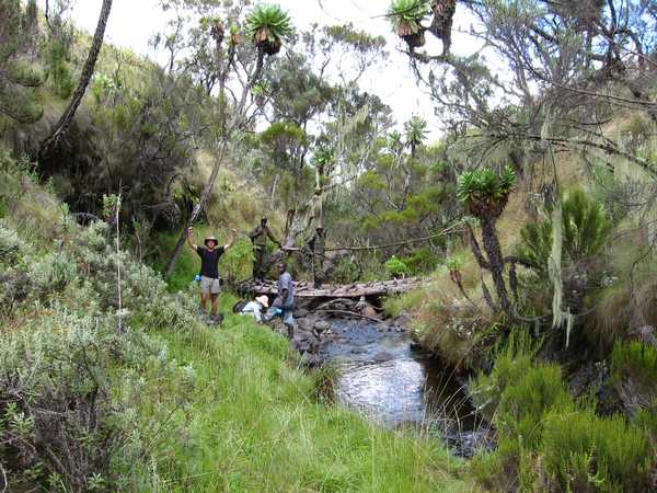
The following day we climbed to the crater rim again, before starting to head down (via a different route) towards the town of Sipi. There were so many steep valleys to cross, but the landscape was beautiful. Forests and streams and small cataracts (eye think that's how it's spelt). Here we are crossing one of the ones that did have a bridge. Cariad washes her face while 'Huck' can't control his emotions at being surrounded by such beauty.
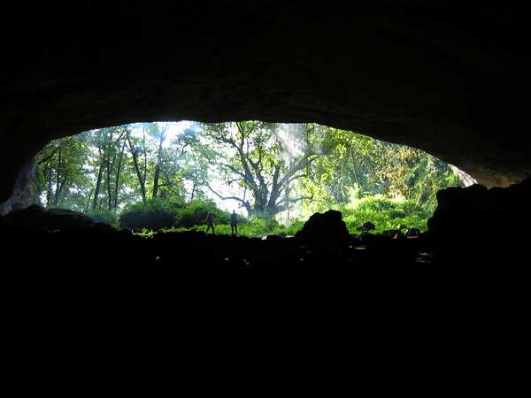
That night we camped in the huge Tutum cave. The cave is home to hundreds of bats (we were surrounded by the evidence, both visually and olefactorally - in other words, it stunk of guano). There was also a waterfall which cascaded across the mouth of the cave in which Mike took a shower. Cariad and I are silhouetted in the mouth of the cave, next to the waterfall.
The following morning (after cleaning the bat sh*t off our tents) we set off for Sipi. Much gentler gradient today (thankfully) and some impressive bamboo forest and a final (very cramped minibus ride to Crow's Nest camp in Sipi, which has views of Sipi Falls.
|
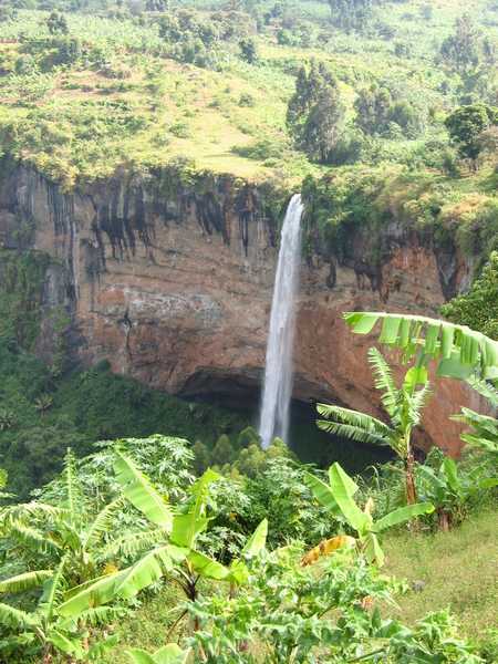
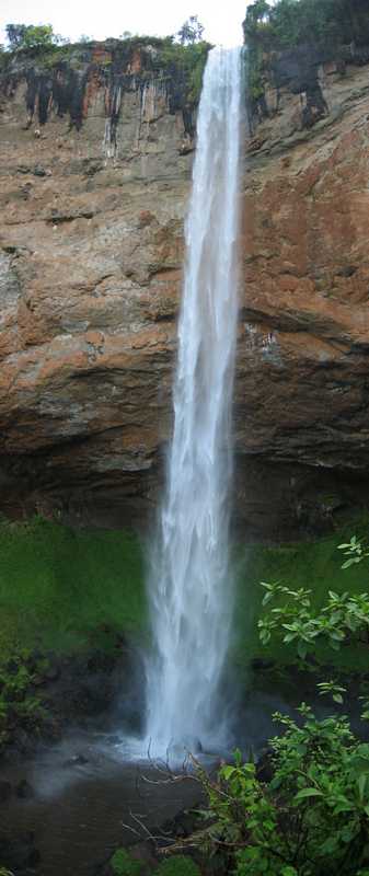
This is the 3rd of the falls at Sipi and the most impressive. |
|
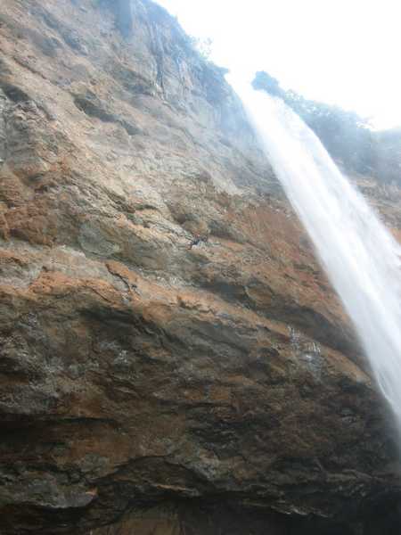
The following day I abseiled down from the top of the falls. I am the grey blob in the middle of the picture, to the left of the falls (about level with the start of this paragraph). |
|
The water falls vertically for 90m, before being dispersed into a fine spray in the pool at the bottom. This meant that when I got to the bottom, I was blasted by a constant spray of water whilst I tried to pick my way across the boggy, muddy ground, which was almost as much fun as the descent itself (but not nearly as scary). |
<< School | Rwanda >>